
|

Start - Finish: We left the car at a crossroad above Roundwood, to reach the Wicklow Way, where it leaves the road.
Distance: 28.5km
Total Ascent: 638m
Total Time: 8 hours
Weather: Scattered showers - Strong wind at altitude
Temperature: From 10 to 18 degrees celcius
Visibility: Good
Difficulty: Very long walk with no technical difficulties - Well marked trail.
Warnings: Marsh land when reaching the end of Lough Dan - Rain and Wind are part of the Wicklow Mountains experience: bring adequate equipment
Fauna: The main attraction is the hurdle of deers down the valley leading to Lough Dan (more than 100?)
Flora: Heather are in full bloom at this time of year
Description:
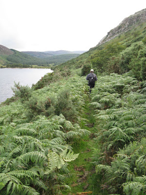
Our first objective was to do a linear walk along the Wicklow Way to reach Djouce Mountain. The scenery and views are stunning with fabulous views over the Wicklow Mountains, Vartry Reservoir, The Irish Seas, The Sugar loaf, Dublin Bay up to Howth, Lough Tay and Lough Dan. After our climb to Djouce Mountain we decided to try to reach the car going down to Lough Dan and walk around it. We reached Inchavore river but couldn't find an easy way to cross it (very deep river running along marsh lands). For safety reasons we decided to walk back up to Lough Tay, then walk along the raod as daylight was waning.
No comments:
Post a Comment